Creugenat
Origin of the name Creugenat
The place also appears as « Creux-Genat » and « Creux-Genaz ». A popular belief links the name to the patois « Creû dè Djenâtches », the « witches' hollow ». Archival research links it instead to the patois « creûjenat », « small hollow », or to the verb « creûjenaie », « to dig », though this is uncertain.[1][2]
Founding of Creugenat
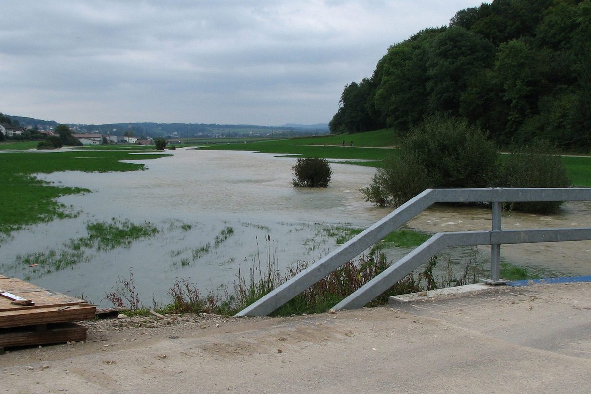
The Creugenat is a natural karst feature: an emissive sinkhole in the Chevenez valley, on the territory of the municipality of Haute-Ajoie (former municipality of Chevenez, merger of 1 January 2009), very close to the boundary with Courtedoux. After heavy rain, the underground river that drains part of the Haute-Ajoie and the Bure plateau, called the Ajoulote, overflows through this sinkhole: a temporary river then crosses the Courtedoux plain and joins the Allaine at Porrentruy. These floods usually occur four to five times a year, in some years ten times or more, and their discharge is typically about 20 m³/s. Studied as early as the 18th century because of the flooding of Porrentruy, the flooded passages were explored from the 1920s and 1930s.[1][2][3]
History of Creugenat
1757. On 22 July, a Creugenat flood inundates Porrentruy.[1]
1778. On 17 August, theses on the Creugenat are presented at the Porrentruy college; others follow in 1782.[1]
1781. In June, an investigation is made of the periodic Creugenat torrent near Porrentruy.[1]
1804. On 2 August, floods of the Allaine and the Creugenat sweep away bridges in Porrentruy and damage the neighbouring villages.[1]
1845-1848. The Creugenat bridge in Porrentruy collapses. It is rebuilt in 1848.[1]
1885. On 25 August, the Porrentruy water commission explores the Creugenat.[1]
1922-1925. Correction works on the beds of the Allaine and the Creugenat in Porrentruy. The town section is accepted on 10 September 1925, and the Confederation refuses its subsidy in 1926.[1]
1926. On 1 August, Albert Perronne, Lucien Lièvre and Frédéric-Édouard Koby explore the Creugenat.[1]
1934. First explorations with helmet divers: divers Spengler and Scherrer, of the Zurich firm Losinger, advance about sixty metres. Pumping works begin in July.[1][2]
1935. A fissure opened at Creux-des-Prés proves to be connected to the Creugenat.[1]
1937. On 19 January, the exploration society SOREA is founded, chaired by Lucien Lièvre.[1]
1973. Gérard Domon, of the Groupe spéléo de Porrentruy, passes the 1934 terminus with autonomous diving. More than 2 km of passages are surveyed.[2]
2000. The Club spéléo de Porrentruy pumps the passages dry up to the 1934 terminus to study them further.[1][2]
2000-2010. Archaeological excavation of an early medieval hamlet about 300 m downstream from the spring (municipality of Courtedoux).[3]
2002. Dinosaur tracks are discovered near the resurgence.[1]
2008. On 10 March, construction begins on the Transjurane viaducts between Courtedoux and Chevenez, including the Creugenat viaduct.[1]
Historic sites in Creugenat
Creux-des-Prés. Shaft giving access to the same underground network. Its connection with the Creugenat was recognised in 1935.[1]
Courtedoux plain. During floods, the temporary river issuing from the Creugenat crosses this plain before joining the Allaine at Porrentruy.[2]
Creugenat viaduct. Structure of the A16 Transjurane motorway, straddling the municipalities of Haute-Ajoie and Courtedoux, whose construction began in 2008.[1]
Remains in Creugenat
Early medieval hamlet of Courtedoux-Creugenat. About 300 m downstream from the spring, on the territory of Courtedoux, the 2000-2010 excavations uncovered two farmsteads occupied from the second half of the 6th century to the first half of the 8th century, with traces of iron working, as well as a small Roman building and prehistoric traces.[3]
Legends of Creugenat
The witches' hollow. According to a popular belief that is still alive, the Creugenat would be the « witches' hollow » (« Creû dè Djenâtches » in patois).[1][2]
Sources
- Denis Moine, Chronologie jurassienne, « Creugenat »
- Showcaves.com, « Creugenat »
- République et Canton du Jura, Office de la culture, Section d'archéologie et paléontologie, Cahier d'archéologie jurassienne 33, résumé (Courtedoux-Creugenat)
- geo.admin.ch (swisstopo), recherche de lieux et limites communales historiques
Other villages near Creugenat
Missing information, or do you have a source? Suggest a correction or addition. Every submission is checked before it's published.
Suggest a change