Cuarny
Flammable gases escaped from the ground at Cuarny: the village put them on its coat of arms, and drillers went down 2'500 metres looking for oil, without success.
Entry based on 7 sources · Our method · Reusable text (CC BY-SA)
Origin of the name Cuarny
The village is mentioned in 1174 as « Quarnie », then « Cuargnier » around 1300 and « Cuarnier » in 1453. The name « Cuarny » still awaits an explanation.[1][2]
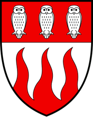
Coat of arms of Cuarny
Argent, three flames gules issuing from the base, on a chief of the same three owls of the first. On a white field, three red flames rise from the bottom of the shield. The top is red, with three white owls. Adopted in 1928, these arms recall the flammable gases that escaped from the ravine. The owls refer to the villagers' nickname, the "Lou-Tsérous".[6][3][2]
Founding of Cuarny
Who founded Cuarny remains unknown. Yet the site was inhabited long before it: excavations carried out during construction of the A1 motorway uncovered a succession of buildings from the Early Bronze Age to the 6th century AD, including a La Tène settlement and water works, notably a Gallo-Roman conduit. The first inhabitants settled near a marsh. In Gallo-Roman times the settlement moved up the hillside. In the Middle Ages the territory belonged partly to the abbey of Montheron and partly to the castellany of Saint-Martin. Around 1300 it may also have belonged to the lords of Floreyres. Under Bernese rule Cuarny was part of the bailiwick of Yverdon. The municipality includes the street village, the estate of Fignerolles and the locality of La Grand-Fin, detached from Pomy. Its inhabitants are nicknamed the « Lou-Tsérous », which the owls on the coat of arms recall.[1][2][3]
History of Cuarny
Early Bronze Age. First inhabitants settle near a marsh (around 1800-1500 BC).[2]
Late Bronze Age and Iron Age. New occupations of the site, including a La Tène settlement.[1]
Gallo-Roman period. The settlement moves up the hillside. Buildings and a Gallo-Roman conduit, with occupations up to the 6th century.[1][2]
1174. First mention, «Quarnie».[1][2]
around 1300. The village appears in the form «Cuargnier».[2]
1325. Mention of a chapel dedicated to Saint Lawrence.[1][2]
1536-1798. Under Bernese rule Cuarny belongs to the bailiwick of Yverdon.
1664. The chapel becomes a subsidiary of the parish of Pomy. The date is uncertain: 1664 or 1648.[1][2]
1763. Construction of the present church.[1][2]
1798. Cuarny joins the district of Yverdon, to which it belongs until 2007.[1]
1802. During the Bourla-Papey uprising, documents are seized and destroyed.[1]
around 1850. Sulphurous and bituminous emissions attract attention.[2]
1908-1909. An engineer recruit school reportedly builds some fifteen concrete or corrugated-iron shelters on the summit of the Montélaz.
1928. Adoption of the coat of arms: three flames recalling the flammable gases of the soil and three owls recalling the inhabitants' nickname.[2][3]
1935. Construction of the school.[1]
1935-1939. Deep drilling to 2'500 metres in search of oil, without success.[2][3]
1964. The locality of La Grand-Fin, detached from Pomy, is joined to Cuarny.[1]
1974-1975. New oil exploration, with no better result.[1]
1993. Archaeological excavations linked to the construction of the A1 motorway.[1][2]
2008. Cuarny becomes part of the district of Jura-Nord vaudois.[4][5]
Population of Cuarny
Sources and references: [1][4]
| 1764 | 182 |
| 1850 | 292 |
| 1900 | 263 |
| 1950 | 203 |
| 1980 | 150 |
| 2000 | 171 |
| 2025 | 244 |
Families of Cuarny
Citizen families before 1800. Bécherraz, Correvon, Gendroz, Gondoux, Guerry, Peguiron and Pigueron, without a precise date.[7]
In the 19th century. The Christin family, without a precise date.[7]
From 1901 to 1962. 8 registrations. Several families come from abroad: from the Soviet Union (von Malm in 1940), from Italy (Fornara in 1955), from Poland (Fatyga in 1957) and from France (Girod in 1962). From Switzerland come the Leu family from Küssnacht am Rigi SZ and the Reusser family from Aeschlen BE (1956) and the Etter family from Kerzers FR (1958). They are joined by the Romanuti family (1935). The last family registered, in 1962, is the Girod family.[7]
Economy of Cuarny, past and present
Gas and oil. After the fumes noticed around 1850, test drillings in 1900 and 1916 try to tap methane from the Cuarny-Cronay ravine, without the hoped-for success. The 63-metre drilling tower, put up in 1935, stands until 1954. A pipe then lets flammable gas escape until the mid-1960s.[2][3]
Fields and forests. In 1976, almost all forest owners join together in a forestry union, part of the Yverdon-Yvonand forestry district since 2022. In the 1990s, building the A1 motorway forces a complete land consolidation of the farming zone. One milk producer and one sheep breeder and dealer remain.[2][3]
Small businesses. Around ten small businesses are based in the village: heating and plumbing, a potter specialising in historical ceramics, a car body shop, a joinery, a landscaper, a stainless steel metalworker, an organic market gardener, a riding centre, a hair salon and an Icelandic pony stud.[3]
Historic sites in Cuarny
Church of Cuarny. Church built in 1763, succeeding the Saint-Laurent chapel mentioned in 1325. The chapel stood on the site of the present cemetery. Cuarny was a subsidiary of the parish of Pomy.[1][2]
Montélaz hill. Highest point of the commune (668 metres), where the army built fortifications. An engineer recruit school reportedly built some fifteen military shelters there in 1908-1909. A television relay antenna was later installed on the summit.[3]
Fignerolles estate. Estate belonging to the commune, formerly part of the property of Montheron Abbey.[1]
Remains in Cuarny
Archaeological sites of the A1 motorway. The 1993 excavations revealed a succession of buildings from the Early Bronze Age to the 6th century AD, a La Tène settlement and water works, including a Gallo-Roman conduit.[1][2]
Military shelters of the Montélaz. Some fifteen shelters of concrete or corrugated zinc sheet, built in 1908-1909 by a recruit school of engineer sappers. An inscription in the concrete reportedly dates one of them to 1909.
Memory of the oil drilling. In 1935-1939 a deep drilling to 2'500 metres was carried out in search of oil, without success. The drilling tower is said to have remained standing until 1954.[2][3]
Traditions and festivals in Cuarny
The Capite. On Friday evenings the inhabitants meet at the Capite, a caravan, for a get-together among neighbours.[3]
Sources
- Philippe Heubi, « Cuarny », Dictionnaire historique de la Suisse (DHS), version du 01.04.2010
- Commune de Cuarny, « Histoire »
- Feuille des avis officiels du canton de Vaud, « Alphabet des communes vaudoises : Cuarny »
- Statistique Vaud, « Population résidante permanente au 31 décembre 2025 »
- État de Vaud, communiqué du 12.07.2007, « Organisation des préfectures et adaptation au nouveau découpage territorial »
- IPI, Swissreg, emblems database: coat of arms of Cuarny (no. 101976)
- Register of Swiss Surnames, 3rd edition (1989), search Commune "Cuarny", Canton VD
Published by Sébastien Jörg ·
Other villages near Cuarny
Missing information, or do you have a source? Suggest a correction or addition. Every submission is checked before it's published.
Suggest a change