Mauborget
The highest village of the Vaud Jura, at 1'170 m, which celebrated the 600th anniversary of its first mention in 2003 by planting a lime tree.
Entry based on 6 sources · Our method · Reusable text (CC BY-SA)
Coat of arms: Public domain, Wikimedia Commons
Origin of the name Mauborget
First mentioned in 1403 as «Malborget», in an acknowledgement of fiefs made to Count Amédée de Savoie by Marguerite de Montbéliard. The name later took the form «Montborget». It is reportedly explained as «mau» (bad) and «borget» (small borough), that is «bad little borough», but this is not confirmed.[1][2]
Coat of arms of Mauborget
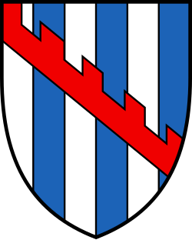
Paly argent and azure, over all a bend embattled gules. The shield is striped vertically in white and blue. A red band with battlements crosses it diagonally, from the upper left corner to the lower right. Mauborget belonged to the barony of Grandson, and in 1921 the municipality took up the arms of its lords. Their bend became embattled, a discreet allusion to the village's name, the "borget" or small market town.[5][2]
Founding of Mauborget
Mauborget lies between the Chasseron and the Mont Aubert, on the road from Grandson to Môtiers (NE). Who founded Mauborget remains unknown. In the Middle Ages the village belonged to the lordship of Grandson and appears in the records among the villages of the mandement of Grandson. Long attached to the community and parish of Fiez, it only became a separate municipality when Fiez was broken up. The village lived from mountain farming and forestry, then from tourism from the beginning of the 20th century.[1][2]
History of Mauborget
Middle Ages. Mauborget is part of the lordship of Grandson.[1][2]
1403. First mention, as «Malborget», in an acknowledgement made to Count Amédée de Savoie by Marguerite de Montbéliard for the castle, town and mandement of Grandson.[1][2]
1484-1798. After the Burgundian Wars, the village is incorporated into the bailiwick of Grandson.[1]
1730. The municipality of Mauborget is formed when Fiez is broken up.[1]
1798. Mauborget is attached to the district of Grandson, to which it belongs until the end of 2007.[1]
1897. In church matters Mauborget, until then attached to the parish of Fiez, passes to the chapelry of Villars-Burquin, made a parish in 1917.[1]
around 1900. Summer tourism flourishes, with the building of a hotel and several guesthouses.[1]
1921. Adoption of the current coat of arms, based on that of the lords of Grandson, with an embattled bend alluding to the «borget» (small borough).[2]
1964. A chapel is built.[1]
late 20th century. Shift towards winter tourism (cross-country skiing, second homes). A network of asphalt roads and active forestry allow mountain farming to continue (five farms in 2000).[1]
2003. On 18 October the village celebrates its 600 years by planting a commemorative lime tree.[2]
1 January 2008. The new Vaud districts (law on territorial division) come into force: the district of Grandson is dissolved and Mauborget joins the district of Jura-Nord vaudois.
Population of Mauborget
Sources and references: [1][4]
| 1803 | 94 |
| 1850 | 126 |
| 1900 | 92 |
| 1950 | 68 |
| 1980 | 41 |
| 2000 | 85 |
| 2025 | 137 |
Families of Mauborget
Citizen families before 1800. Périllard, Roulet and Simon, without a precise date.[6]
In the 19th century. The Périllat, from Duillier VD, are registered without a precise date, the André of Montalchez NE in 1852.[6]
From 1901 to 1962. Fourteen registrations. The Gillardet open the list in 1919. Next come the Michaud, from France (1932), the Poli, from Italy (1933), the Battailard (1937), the Linemann, from Germany (1944), and the van Schelven (1950). The 1950s bring families from Austria (Schusser, 1953), Yugoslavia (Kordon in 1953, Stojanovic in 1956) and Italy (Bréa and Peradotto in 1954, Rigazzi in 1957). Also in 1957, two Neuchâtel families are admitted: the Petitpierre of Couvet and the Procureur of Enges.[6]
Economy of Mauborget, past and present
Mountain farming and forest. A network of asphalt roads and intensive use of 350 hectares of forest allowed mountain farming to survive, with five farms in 2000. According to the FAO, four farmers remain, one of them a milk producer. They rent municipal land and two municipal alpine pastures located in Fontaines and Grandevent.[1][2]
Tourism. A hotel and several guesthouses started summer tourism. Towards the end of the 20th century, the village turned more to winter tourism. According to the FAO, a cooperative runs a ski lift, also known for its télébob, and cross-country ski trails run through the area. The village has no shop, dairy or post office, but keeps a café-restaurant.[1][2]
Historic sites in Mauborget
Village of Mauborget. At 1'170 m above sea level, it is the highest village of the Vaud Jura. In clear weather the view extends over the whole chain of the Alps.[1]
Mauborget chapel. Chapel built in 1964; the village, which previously had no church of its own, belonged to the parish of Fiez and, from 1897, to Villars-Burquin.[1]
600th anniversary lime tree. Lime tree planted on 18 October 2003 to commemorate 600 years since the first written mention of the village.[2]
Traditions and festivals in Mauborget
The Tsayiu. The people of Mauborget are nicknamed "lè Tsayiu", the jealous ones.[2]
Sources
- Dictionnaire historique de la Suisse, « Mauborget » (Philippe Heubi, version remaniée du 17.12.2009)
- Feuille des avis officiels du canton de Vaud, « Alphabet des communes vaudoises : Mauborget »
- État de Vaud, communiqué du 12.07.2007, « Les préfètes et les préfets sont attribués aux nouveaux districts »
- Statistique Vaud, « Population résidante permanente au 31 décembre 2025 »
- IPI, Swissreg, emblems database: coat of arms of Mauborget (no. 101595)
- Register of Swiss Surnames, 3rd edition (1989), search Commune "Mauborget", Canton VD
Published by Sébastien Jörg ·
Other villages near Mauborget
Missing information, or do you have a source? Suggest a correction or addition. Every submission is checked before it's published.
Suggest a change