
Randa
Origin of the name Randa
The village is first mentioned in 1305 as « Randa ». Where does the name come from? That is still unknown.[1]
Founding of Randa
Randa is a municipality in the district of Visp, in the Mattertal (Nikolaital), comprising the village of Randa and the hamlets of Lerch, Wildi and Attermänze. From the 13th century to 1552, Randa belonged to the majorie, then the castellany of Naters. It then formed with Täsch a castellany belonging to the majorie of St. Niklaus (free jurisdiction). Its communal statutes date from 1593, and in 1798 Randa became a political municipality, separate from Täsch. In church matters, the village belonged to the great parish of St. Niklaus until a rectorate was founded in 1730, and then became a parish. Long dependent on poor farming and some livestock, the village, lying on the road to Zermatt, opened up to tourism after 1850 and soon had nearly thirty mountain guides. At the start of the 21st century, a large share of the inhabitants work in tourism and crafts, and water royalties bring the municipality considerable income.[1]
History of Randa
13th century. Randa belongs to the majorie, then the castellany of Naters, until 1552.[1]
1305. First mention as « Randa ».[1]
1552. Randa forms with Täsch a castellany belonging to the majorie of St. Niklaus (free jurisdiction).[1]
1593. Communal statutes.[1]
1636. An ice fall from the Bies glacier strikes the village, killing 37 people.[1][6]
1716. The church is built.[1]
1720. Another ice fall from the Bies glacier.[1]
1730. A rectorate is founded, detaching Randa from the great parish of St. Niklaus; Randa later becomes a parish.[1]
1737. Another ice fall from the Bies glacier.[1]
1798. Randa becomes a political municipality, separate from Täsch.[1][3]
1819. Another ice fall from the Bies glacier.[1]
1844. The boundary with Täsch is fixed.[3]
1860-1861. The first hotel is built.[1]
1927. The church is enlarged.[1]
1991. A rockslide in several phases from 18 April buries the hamlet of Unterlerch: about 30 million m³ of material cut the road and railway to Zermatt, without any human casualties.[1][6][7]
2017. On 29 July the Charles Kuonen suspension bridge on the Europaweg above Randa is inaugurated.[8]
Population of Randa
Sources and references: [1][4]
| 1798 | 140 inhabitants |
| 1850 | 161 inhabitants |
| 1900 | 271 inhabitants |
| 1950 | 369 inhabitants |
| 2000 | 404 inhabitants |
| 2025 | 448 inhabitants |
Historic sites in Randa
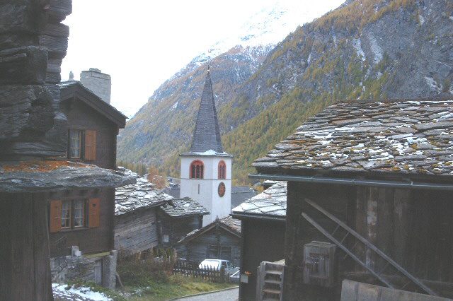
Parish church of Saint Sebastian. Church built in 1716 and enlarged in 1927, housing a valuable Baroque high altar by Anton Sigristen.[1]
Lerch and Unterlerch. Hamlets of the municipality; Unterlerch was buried by the rockslide of 1991.[1]
Bies glacier. Glacier whose ice falls struck Randa several times, notably in 1636, 1720, 1737 and 1819.[1]
Europahütte and Charles Kuonen suspension bridge. Hut at 2'265 m, reportedly at the junction of the Europaweg and the Domhütte path. On the Europaweg above Randa, the Charles Kuonen suspension bridge was inaugurated in 2017.[8]
Sources
- Dictionnaire historique de la Suisse, « Randa » (Bernard Truffer, version du 27.07.2010)
- Historisches Lexikon der Schweiz, « Randa » (version allemande, 27.07.2010)
- Dictionnaire historique de la Suisse, « Täsch » (Bernard Truffer, version du 06.03.2012 ; frontière de 1844)
- Office fédéral de la statistique (OFS), STATPOP, chiffres provisoires au 31.12.2025, via citypopulation.de
- geo.admin.ch, recherche de lieux (coordonnées de Randa)
- Blick (Keystone-SDA), « Naturkatastrophe im Wallis : vor 30 Jahren verschüttete ein Bergsturz einen Teil von Randa » (18.04.2021)
- Walliser Bote (1815.ch), « Naturkatastrophe : Randa blickt zurück » (07.05.2016)
- freizeit.ch, « Längste Hängebrücke der Welt ist eingeweiht » (Charles Kuonen Hängebrücke, 29.07.2017)
Other villages near Randa
Missing information, or do you have a source? Suggest a correction or addition. Every submission is checked before it's published.
Suggest a change